
Reports, Reporting for Duty
At Maurer-Stutz Geospatial Services, we have many projects that require reporting. Today, we want to help other ArcGIS Pro users utilize the reporting functions built within that system in an easy and effective way.
Utilizing ArcGIS Reports
At Maurer-Stutz Geospatial Services, we have many projects that require reporting. Today, we want to help other ArcGIS Pro users utilize the reporting functions built within that system in an easy and effective way.
The Reports function allows you to quickly generate a report from your data. You can:
Display only the fields you specify for each feature.
Add visual elements like graphs and charts.
Filter the data to show only what’s relevant to the purpose of the report.
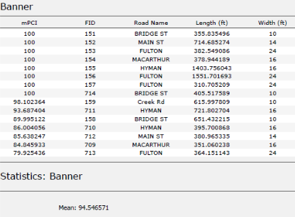
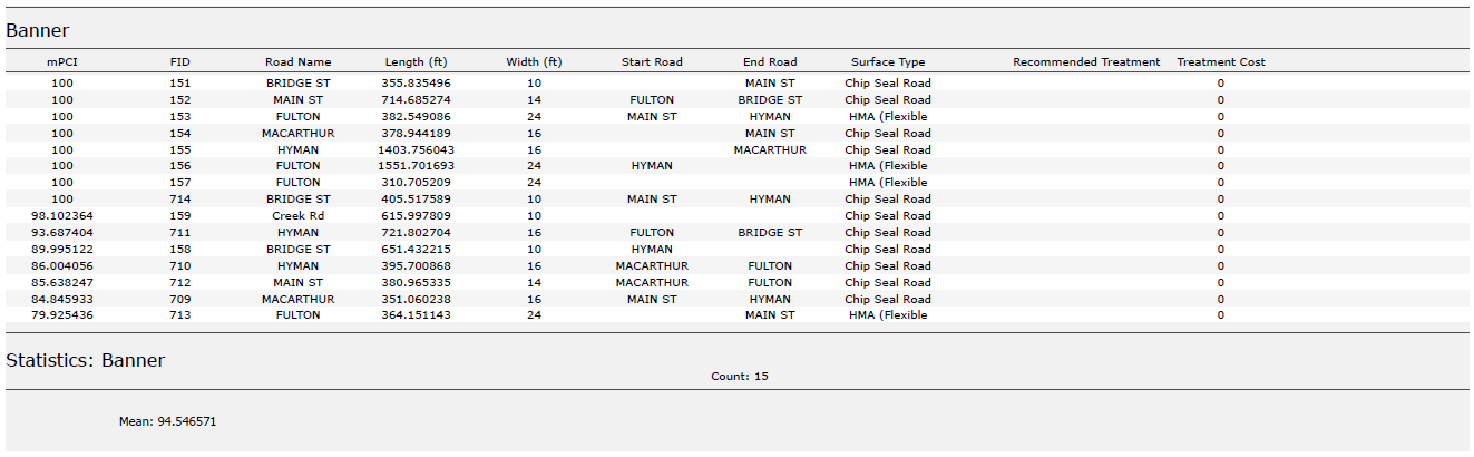
In this example, I used road assessment data as my source, and wanted to create a report showing me each road across 11 different towns, sorted from worst to best based on their score (mPCI).
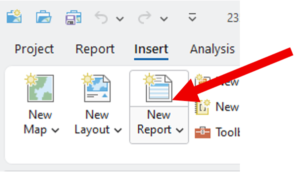
Step 1: Select Your Data
Select the map frame that contains the data you want to use.
Go to the Insert tab and click New Report.
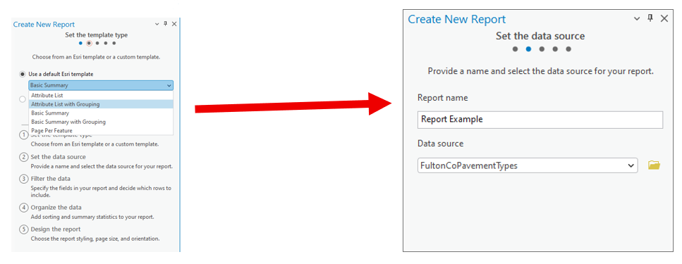
Step 2: Choose a Template
Select a report template.
Example: Choose Attribute List with Grouping.Name your report.
Select the data source (the dataset you’ll report on).
Step 3: Organize the Data
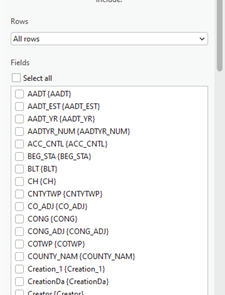
Choose the fields you want to display.
Example: For a road assessment, include:Road Name
Assessment Score
Length
Width
Material
Other relevant details
Tip: Drag and drop fields to reorder them in the report.
2. Select a grouping field to organize your report.
Example: Group by Municipality.
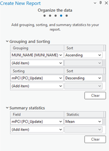
3. Define sorting rules within each group.
Example: Sort roads by Assessment Score (descending),
so the lowest scores appear first.
4. (Optional) Add group statistics:
Choose a field (e.g., Assessment Score).
Select a statistic (e.g., Mean) to summarize each group.
5. Set your page size and click Finish.
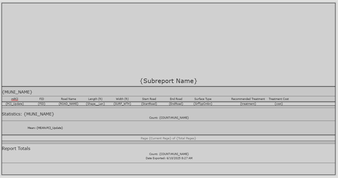
Step 4: Preview the Report
Your report will now display:
Each road grouped by municipality.
Roads within each group sorted by assessment score.
You can rename column headers to make them more readable.
(Just like editing text in Layout View.)
Step 5: Export the Report
Export the report as a PDF or another supported format.
Your final report will include:
Organized, grouped, and sorted data.
Optional charts, statistics, or summary sections if added.
Additional Tips
Use the Insert tab to:
Add more fields or statistics after the report has been created.
Insert charts, dynamic images, or text blocks.
Choose where these additions appear:
Statistics Group: Appears at the end of each group (e.g., each municipality).
Report Totals: Appears at the very end of the full report.
We hope this has been a casual guide to creating reports in ArcGIS. It walks you through generating a report from your data, showing you how to pick what information to display, add visuals like graphs and charts, and filter what's relevant. You'll learn how to select your data, choose a template, organize your information by grouping and sorting, preview your report, and finally, export it as a PDF or other format. There are also some neat tricks for customizing your report, like adding more fields or charts after it's been created
If you have other questions please don’t hesitate to contact us in the form below.

One Year With Engineers
A year ago, I walked into Maurer-Stutz with a mission: to build something new, something purpose-driven, something lasting. That something became Maurer-Stutz Geospatial Services (MSGS). Now, 12 months in, I can confidently say we’re not just building a team—we’re building momentum

One Year at Maurer-Stutz: Building a Geospatial Foundation for the Future
A year ago, I walked into Maurer-Stutz with a mission: to build something new, something purpose-driven, something lasting. That something became Maurer-Stutz Geospatial Services (MSGS). Now, 12 months in, I can confidently say we’re not just building a team—we’re building momentum.


Starting From the Ground Up
When I joined the company on April 29, 2024, the Geospatial Department was more of an idea than an entity. With one GIS Specialist; Katie Kopkowski, who stuck around to be the anchor, we had talent, but we needed direction, structure, and an identity. I knew from the beginning that MSGS couldn’t be “just the map guys” on engineering projects. MSI leadership wanted us be strategic partners, not just a service department. Trusted advisors, not only task-takers.
Beigin at the begining
So, we began with the essentials. Working through the process as if we were starting a new business, but with the advantage of having supporting oversight structure.
Conducted a full assessment of existing software, hardware, and workflows.
Evaluated team strengths and gaps in a SWOT analysis.
What engineering clients existed and which represented low-hanging fruit.
Built a business plan with a six-year growth strategy, aligning revenue goals with staffing targets and market segments.
Developed mission and vision statements to clarify who we are—and who we are not
Building the Right Team
This work isn’t possible without people. I’m proud to lead a growing team that now includes Geospatial Engineer Baylor Wagehoft, fellow ISU Redbird Ethan Geisler, and Geospatial Intern Michelle Wagehoft. Next month, we will welcome our sixth employee who will focus on the Agricultural market. Each team member brings a unique set of strengths to the table and we’ve focused on creating a collaborative culture built on professionalism, mutual respect, and shared accountability with our Team Operations Manual (T.O.M.)

Growing with Purpose
In just one year, we’ve:
Supported multiple infrastructure and fiber deployments with precision GIS solutions.
Partnered with our own MSI engineering groups without becoming “support-only” on projects.
Initiated the modernization client GIS and database migration and tuning.
Established professional partnerships in cloud architecture, economic development, utilities, and broadband.
A key part of our journey has been thoughtfully drawing a line between the way things have traditionally operated at MSI and the direction we're heading—evolving from a service-oriented support group into a focused, independent, growth-focused team—a shift that will require continued clarity, communication, and collaboration as we grow. We’re becoming a revenue-generating, client-facing, innovation-focused business unit. And our identity is no longer in question—we are MSGS, and we are growing.
Looking Ahead

Up And To The Right!
Year one was about foundations. Year two is about scaling.
We’re focused on:
Expanding our managed services offerings.
Growing cloud GIS capabilities.
Deepening client relationships and building repeatable solutions.
Recruiting talent that shares our drive for innovation and excellence.
I’m grateful for the leadership at Maurer-Stutz inc. for supporting this vision, and for my team for embracing the challenge. This isn’t just about GIS—it’s about transformation. At MSGS, our mission is: To transform our clients' and industry partners' unique visions into reality through specialized geospatial expertise. Our B.H.A.G. is: By 2030, MSGS will be a recognized leader in geospatial services industry by providing solutions in the broadband, utility infrastructure, and consultant engineering domains.
Here’s to year two—and all the vision, trust, and growth it will bring.
We will accomplish this by delivering quality services with integrity, care, and efficiency. Working with you by design.
Email us for more information:
Introducing: Geospatial Solutions Plans
Maurer-Stutz Geospatial Services is excited to introduce our newest contracting solution, Geospatial Solutions Plans! These subscription-based, block-of-hours contracts are idea for organizations large and small that need the flexibility of a top tier geospatial consultant on demand.
Geospatial > The Layer File > Geospatial Solutions Plans

At Maurer-Stutz, “Working with you by design” is more than just a motto—it’s a promise. We believe every organization’s challenges are unique, and so are the solutions needed to address them. In the consulting world, this has typically meant project-based contracts reign supreme – scopes and costs are defined up-front with little wiggle room for change without renegotiation.
While these types of contracts certainly have their place, what if you don’t know what your needs are in advance? Is a fixed contract the best use of your organization’s time and resources? In some cases, long-term contracts and one-size-fits-all projects can leave you feeling boxed in.
Dynamic organizations deserve a partner that can be dynamic with them. That’s why at MSGS we’ve introduced our Geospatial Solutions Plans (GSPs): a flexible, subscription-based consultant model that delivers high-level GIS expertise through pre-paid blocks of hours.
With our GSPs, you’ll enjoy budget certainty, scalable support, and the peace of mind that comes from having a dedicated partner by your side—one who truly understands your vision and is ready to adapt to your evolving needs. In this blog, we’ll show you how working together by design leads to better, more responsive geospatial solutions, no matter your organization or industry focus.
What Are Our Geospatial Solutions Plans (GSP)?
Our GSPs are contracts designed for clients that need top-tier geospatial expertise without the stringent commitments of traditional, project-based agreements. With our subscription model, you purchase a block of consulting hours that you can use as needed throughout the plan year.

This means:
Flexible Support: Access expert advice and technical support on demand.
Cost Predictability: Know your expenses upfront with a pre-paid block of hours.
Scalable Engagement: Adjust the level of support as your project needs evolve.
How the Subscription Model Works
When engaging customers on our GSPs, we start with a thorough onboarding process to understand your unique challenges and goals. Here’s what you can expect:
Initial Consultation & Needs Assessment:
Before anything is signed, we will discuss your objectives and current geospatial challenges. This step ensures that the GSP plan level is tailored to your requirements. Our goal is to “right size” the package to fit your anticipated needs.Customizing Your Service Package:
Based on this assessment, we recommend a subscription level (block of hours) that fits your organization’s scope. These hours can be used for a wide variety of GIS consulting services across many different industries (examples below!).Subscription Check-Ins:
We schedule regular check-ins to make sure your organization’s needs are being met efficiently and effectively. This iterative process helps us fine-tune our solutions and ensure continuous improvement throughout the life of the subscription. If your organization is finding value in our consulting services, you can move to a higher plan level as needed.
Renewal
The GSP is an annual subscription. We will never force you to use your consulting hours, and unused hours will roll over to the next subscription plan year. You have the freedom to use them on smaller projects or save them for several years.

Tailored Services That Fit Your Industry
With our Geospatial Solutions Plans, you get full access to our skilled team of dedicated developers, GIS Analysts/Professionals, and Enterprise Administrators who are ready to meet the specific needs of your organization. From Municipal Governments, to Engineering Consultants, to Fiber Broadband Providers, we have the right combination of talent and experience to provide a wide variety of geospatial consulting services.


ESRI Utility Networks
ArcGIS Online Administration
Infrastructure Asset Inventories
Cadastral & Administrative Data Management
Custom Maps, Apps, and Dashboards
ArcGIS Hub Sites and ArcGIS Solutions Deployments
Authoritative Data sourcing & truthing
GIS/CAD/Survey Integrations
JULIE Design Tickets
Geospatial Analysis
Engineering Modelling Inputs
Custom Field Data Applications
Map and Data Report Deliverable Development
ArcGIS Enterprise Deployments
Database Maintenance & Cleanup
Splice Record Imports
Custom Scripting
3rd Party Integrations
Construction Planset Templates
The Benefits of a Block-of-Hours Model
Choosing our subscription-based GSPs means embracing a new level of flexibility and partnership:

On-Demand Expertise: No need to commit to a rigid scope-defined contract—use your hours whenever the need arises.
Predictable Budgeting: With pre-paid hours, you can manage expenses more effectively without unexpected costs. GSPs are calculated based on a discounted average hourly rate when compared to straight time/material contracts. This translates into savings for your organization over the life of the subscription.
Managed Services: For those customers that need ongoing support and maintenance of their GIS deployments, we offer Managed Services within our higher GSP plan levels. This service guarantees weekly check-ins to your infrastructure for performance, maintenance and longevity tasks to keep your GIS deployments running smoothly.
Long-Term Partnership: This model fosters a close, ongoing relationship that allows us to develop a deep understanding of your organization and its geospatial needs.